Notice: WP_Block_Type_Registry::register was called incorrectly. Block type names must contain a namespace prefix. Example: my-plugin/my-custom-block-type Please see Debugging in WordPress for more information. (This message was added in version 5.0.0.) in /var/www/html/urbanwater_prod/wp-includes/functions.php on line 4784
Central city WSUD tour | City of Melbourne Urban Water

Central city WSUD tour

Click through the sections below as you go on a self-guided walking tour of Water Sensitive Urban Design in the Melbourne central city.

You can use your mobile device to access this tour on site, or download the printable version from the menu on the right.

This tour begins at Burston Reserve, a small park located between Parliament Place and Macarthur Street at the eastern edge of the central city.

At Burston Reserve, make your way to the top corner of the park, where Macarthur Street meets Parliament Place. This is Stop 1.


Burston Reserve (1)

Project location

Share this page

Tour information

Stop 1: Burston Reserve raingarden tree pits

In 2012 the City of Melbourne released its Urban Forest Strategy. The strategy outlines the importance of the urban forest and green open spaces in cooling the city and adapting to climate change.

At this time, several of the trees in Burston Reserve had either been removed or were in very poor health. The reserve was upgraded to increase its green footprint and open space and to become a water sensitive landscape.

The park redesign included:

  • Expanding turf and garden areas and reducing the width of surrounding footpaths.
  • Installation of three new raingarden tree pits to capture stormwater runoff from Macarthur Street.
  • Installation of two soaker pits to capture runoff and direct it to four new trees.
  • Removing and replacing declining trees and planting additional trees.

At Stop 1 you can see the three raingarden tree pits within the pavement. These trees are younger than most of the other trees in the reserve.

Burston-Reserve-5_02

How do the raingarden tree pits work?

Each raingarden tree pit works like a small raingarden. When it rains, stormwater runs off road surfaces and into the gutters.

The raingarden tree pits are set into the kerb along Macarthur Street. They intercept and clean the water before it goes into the drain.

Each pit contains layers of substrate that work with the tree’s root system to filter pollution from the stormwater. This includes nitrogen, phosphorus and oils.

The tree pits also include a rock mulch layer to retain moisture in the soil and prevent erosion during rain.

A grate sits around the base of the tree, flush with the pavement. This protects the tree pit from damage and ensures that pedestrians don’t trip over it.

A pipe is located at the bottom of the well. It allows cleaned stormwater to drain back into the drainage system.

12981-CoM-Raingarden-infographic-Tree-Pit-1090px

To move on to the next stop walk along the Macarthur Street edge of Burtson Reserve until you have reached the green and yellow historic tram stop, where the trees in the footpath are fully grown. This is Stop 2.

Stop 2: Burston Reserve infiltration pits

You are standing on the footpath along Macarthur Street, looking at the large trees within the footpath.

Underneath the footpath there are two infiltration pits that allow water runoff from the road to access the root systems of these trees. The pits have been installed between the trees. Although you can’t see the pits, you might notice the grated inlets in the kerb that allow water to flow into the pit.

How do the infiltration pits work?

These pits capture water runoff from the road, irrigating the trees on either side, cleaning the water and reducing stormwater runoff volumes.

A slotted drainage pipe runs through the centre of the pit, connecting to a drainage hole in the gutter. This allows water to flow from the gutter into the pit, where it gradually soaks out into the tree root systems.

To learn more about the Water Sensitive Urban Design at Burston Resrve, read the full case study.

The infiltration trench in Burston Reserve captures water from the road to water the trees.

The infiltration trench in Burston Reserve captures water from the road to water the trees.

To move on to Stop 3, cross the road at the pedestrian crossing and make your way across Gordon Reserve towards Little Collins Street. Cross Spring Street at the pedestrian Crossing and walk about 20 metres down Little Collins Street on the left hand side until you reach the tree with the plaque beside it. This is Stop 3.

Stop 3: Raingarden tree pits on Little Collins Street

You are standing beside a raingarden tree pit.

This raingarden tree pit work in the same way as the one is Burston Reserve, however it is covered with a bluestone plate for pedestrian safety and to protect the tree. As you walk down Little Collins Street to the next stop, take notice of the many raingarden tree pits along the way.

Lt Collins st Raingarden Tree pits 21 July 2008 010

To make your way to the next stop, continue down Little Collins Street. When you reach Swanston Street and the Melbourne Town hall, turn left. Walk to the next intersection and turn right into Collins Street. Walk along Collins Street for one block and cross over Elizabeth Street. Continue along Collins Street for about 50 metres until you notice the checkerboard pattern in the bluestone paving between the trees. This is Stop 4.

Stop 4: Permeable bluestone pavement on Collins Street

You are standing on Collins Street, looking at the strip of checkerboard-patterned bluestone pavement that runs between the trees. This is permeable bluestone pavement.

_MG_8835

Since the early 1980s the City of Melbourne has been upgrading the footpaths in the central city from asphalt to sawn bluestone pavers.

Bluestone paving is a defining element of Melbourne’s character – you will have seen much of it on the tour so far. It is a durable and long-lasting surface that improves footpath accessibility, especially for disabled community members.

However, standard bluestone paving is impermeable or sealed – it does not allow water to pass through. Rainwater collected on the paving flows into the drains and out to the Yarra River. It gathers litter and pollution along the way.

Here in Collins Street, we trialled a new approach to installing permeable bluestone, that allows rainwater to soak down between the pavers. This improves soil moisture and waters the adjacent trees.

Since the successful Collins Street trial, we have installed permeable bluestone paving in several locations across the central city, as you will see on your way to the next stop.

How does the permeable bluestone pavement work?

Typically, bluestone pavers are laid on top of a concrete slab. However, to create the permeable bluestone pavement, the pavers were laid on top of several layers of free-draining structural soil and sand instead.

The pavers were laid with a permeable strip around them that was filled with fine crushed rock. This permeable paving was laid in a strip between the street trees, parallel to the road.

Rainwater now hits the permeable paving, soaks into the soil below and waters the tree root systems.

The permeable paving strip also intercepts water that runs off the non-permeable bluestone. It redirects water that would have flowed directly into the gutter and bypassed the trees.

To learn more about the permeable bluestone pavement, read the full case study.

To move on to the next stop, continue along Collins Street until you reach King Street. At King Street, turn right and then turn left into Little Collins Street. Walk along Little Collins Street until you reach Godfrey Street, on the right hand side. This is Stop 5.

Stop 5: Godfrey Street greening project

You are standing at the corner of Godfrey Street and Little Collins Street, looking down Godfrey Street.

On hot days, Melbourne’s urban area can be up to four degrees hotter than surrounding areas, as a result of the urban heat island effect. Excessive temperatures pose health risks to the community and environment, and impact on business productivity.

Thermal imagery taken in 2010 shows Godfrey Street is a hot spot. Heat is retained in the road, pavement and surrounding buildings.

What did the greening project involve?

We redeveloped Godfrey Street Laneway to cool it by adding trees, vertical greening and rainwater irrigation. We also improved amenity by reducing the road from two lanes to one. This created a larger pedestrian space and allowed for street café trading.

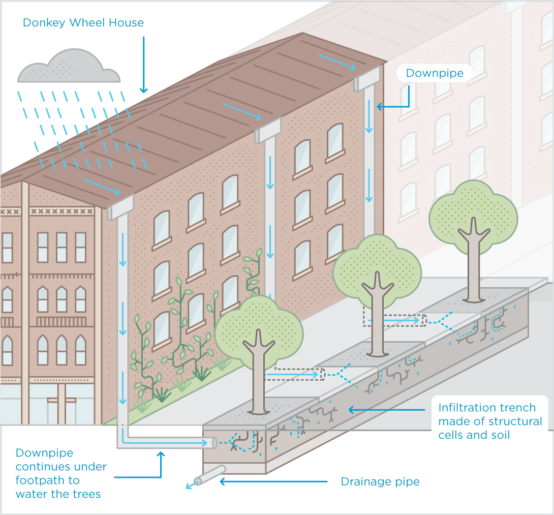
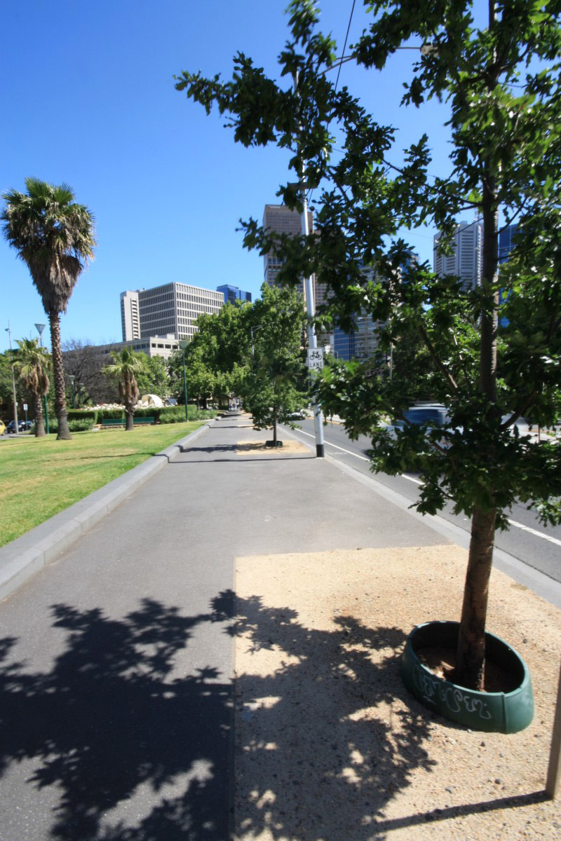
Rainwater is now collected from the roof of a large building (the Donkey Wheel House heritage building on the right) and diverted into a trench of structural cells beneath the footpath. This allows rainwater to passively irrigate the new trees in the trench, you can see the young trees in the footpath ahead. Some rainwater is also diverted to a new garden bed at the southern end of the street.

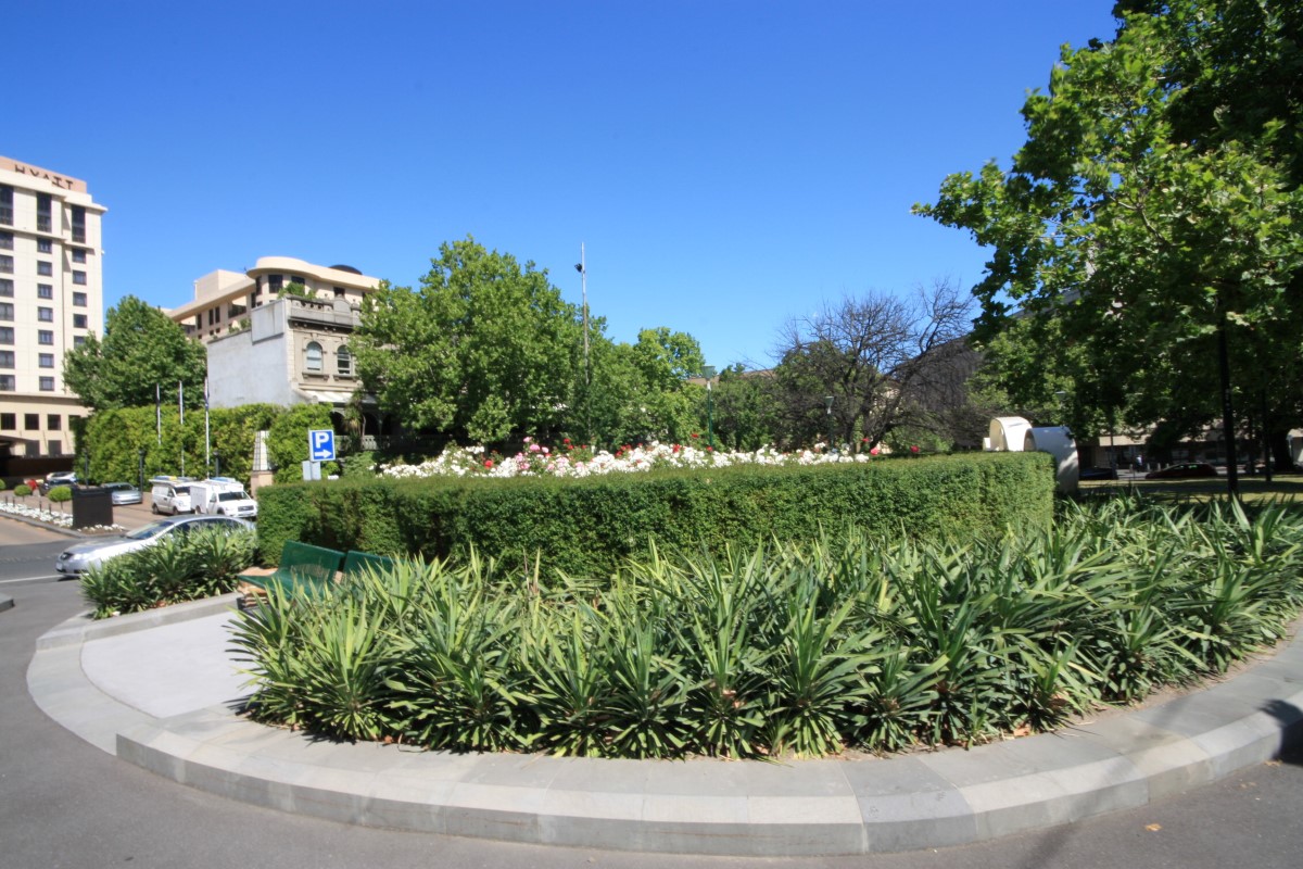
A green façade was also included in the streetscape design. It will grow up the side of the Donkey Wheel House building from a garden bed at the base of the wall (near the Bourke Street intersection). Once fully grown, the green façade will provide additional cooling in the street.

The owners of the adjacent café maintain the garden bed, and also use it to grow herbs.

How does the passive irrigation system work?

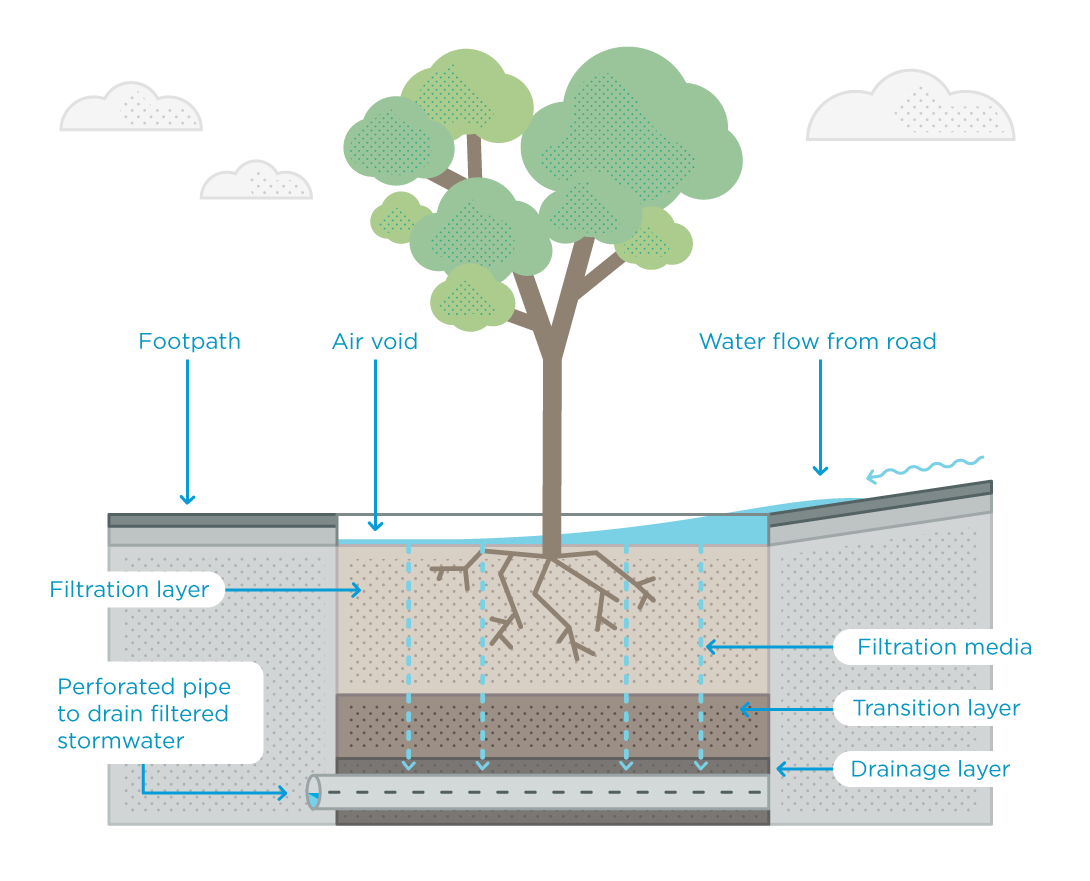
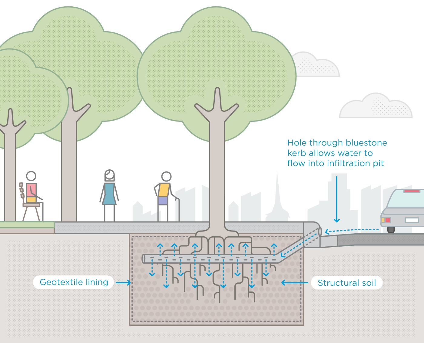
The Donkey Wheel House is the large heritage building that occupies approximately half of the eastern street frontage along Godfrey Street. Rainwater is captured on the roof of the building and flows into five downpipes, spaced along the façade. The new passive irrigation system redirects rainwater from these existing downpipes to the trees and garden in the street.

12981-CoM-Godfrey-Street-Infiltration-Trench-1090px

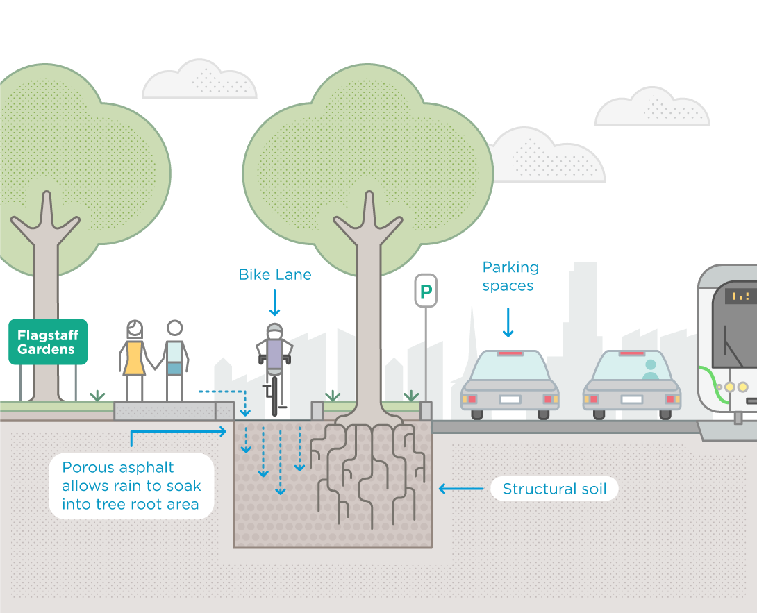
An underground trench

We have redirected three of the downpipes into an underground channel of structural soil and structural cells beneath the pavement. Runoff from the footpath is also directed into the channel via the grill in the pavement.

We have planted trees along the channel. When the water soaks into the structural soil it passively irrigates the trees. The roots of these trees are able to grow freely along the channel, giving the tree a stable base and encouraging vigorous canopy growth.

Garden bed

At the southern end of Godfrey Street (the Lt Collins Street intersection), stormwater is diverted from two downpipes on Donkey Wheel House into a roadside gutter that flows into a garden bed. This provides passive irrigation to the shrubs and trees in the garden bed. It also removes pollution from the water. In heavy rain, excess water is able to flow out from the garden bed and into the stormwater drain. This prevents flooding.

To move on to the next stop, turn right onto Bourke Street and continue to the next intersection. Turn left onto King Street and continue to La Trobe Street. At La Trobe Street, cross the intersection to Flagstaff Gardens. This is Stop 6.

Stop 6: La Trobe Street permeable bike lane

You are standing at the corner of King Street and La Trobe Street, on the edge of Flagstaff Gardens. You can walk along the edge of the gardens, following La Trobe Street, observing the separated bike lane to the right.

As part of our Bicycle Plan 2012-16, a separated bicycle lane was scheduled for construction along La Trobe Street.

We took the opportunity to combine tree planting, passive irrigation and the separated bicycle lane into one piece of infrastructure.

It was important to incorporate the tree planting during construction. Once the bike lane was built it would be difficult and expensive to apply water sensitive urban design.

La Trobe Street is the northern boundary of the central city grid. Thermal imagery shows La Trobe Street is one of the hottest parts of the city, so increasing canopy cover was a priority.

Adding canopy cover is an important part of our climate change adaptation program. Trees provide shade and cool the air, creating a cooler city.

La Trobe Street is very wide, so we couldn’t create a canopy covering the street by planting trees in the footpaths. By planting trees in the bike lane median, we created broader canopy cover.

How does the permeable bike lane work?

The separated bicycle lane was installed along the full length of La Trobe Street. The stormwater capture and greening was trialled on the section between King Street and William Street.

The new bicycle lane is separated from vehicle traffic by a thin median strip. This median includes specially designed tree plots that capture stormwater as it runs off the road surface. This provides passive irrigation for the new trees. Structural soil is used in the tree plots to ensure that the water is able to filter down to the root system.

12981-CoM-La-Trobe-Street-Bike-Lanes-1090px

You have completed the tour!

Get social with the City of Melbourne
This website was delivered in partnership
with the State Government of Victoria
This website was delivered in partnership with the State Government of Victoria