Notice: WP_Block_Type_Registry::register was called incorrectly. Block type names must contain a namespace prefix. Example: my-plugin/my-custom-block-type Please see Debugging in WordPress for more information. (This message was added in version 5.0.0.) in /var/www/html/urbanwater_prod/wp-includes/functions.php on line 4784
East Melbourne walking tour | City of Melbourne Urban Water

East Melbourne walking tour

Click through the sections below as you go on a self-guided walking tour of our water projects in East Melbourne. You can use your mobile device to access this tour on site, or download the printable version from the menu on the right.

This tour begins on Darling Street, East Melbourne, adjacent to Darling Square. You will notice the grassy centre median in Darling Street, and the oval-shaped pump cage within Darling Square. This is Stop 1.


12981-CoM-East-Melbourne-tour-MAP-1090px


Click through the sections below as you go on a self-guided tour.

Project location

Share this page

Tour details

Stop 1: Stormwater harvesting at Darling Street

Beneath Darling Street is a stormwater harvesting system that provides treated stormwater to irrigate neighbouring parks and tree medians, including Darling Square, Powlett Reserve and medians in Grey, Simpson, Powlett and Albert streets. It was constructed in 2011.

Interp Sign Darling Street - Copy

The first stormwater harvesting system constructed in the City of Melbourne, the system works by harvesting stormwater from two nearby existing drains. After the stormwater is diverted from the drains it passes through a litter trap and sedimentation chamber to remove debris, litter and particulate matter. It is stored in a large underground tank and gradually pumped back to the surface where it soaks through the biofiltration bed. This is the garden bed that makes up the median in Darling Street. If you visit this site during summer, you might see water being pumped into the biofilter and soaking through the layers of sand. This process removes nitrogen and phosphorus from the water.

From the biofilter, the water flows into a holding tank beneath Darling Street where it is stored until need for irrigation. The oval cage in Darling Square holds the pump controls for this system.

The project took advantage of a local streetscape upgrade – including replacement of poor performing golden elms, modification of tree islands and resurfacing of roadway – to trial what was a new approach for the City of Melbourne at the time.

 To move on to the next stop, walk 50 metres south to the intersection of Gipps Street and Darling Street. Notice the median in the centre of the road. This is Stop 2.

Stop 2: Gipps Street median

At Stop 2, you are standing in Powlett Reserve, looking across at the grassy centre median in Gipps Street.

4

Gipps Street is a 650 metre long residential street between Coventry Street and Hoddle Street in East Melbourne. A high water table in the area has resulted in waterlogged soil along the sides of the street. This has made it difficult to successfully grow trees in the footpaths.

The City of Melbourne was approached by residents requesting that a centre median with trees be constructed. They wanted a consistent aesthetic with the other streets in the neighbourhood.

In response to the community’s request and the waterlogging issues, a median was constructed along the centre of the street and planted with trees and grass. The design includes underground pipes that capture excess water from the side of the street, redirecting it to the median. This simple solution removes excess water from the root system of the footpath trees and provides passive irrigation for new trees in the centre median.

How the system works

A high water table is present along the sides of Gipps Street, but not under the centre of the road. The basic design concept was to redirect excess water from the edge of the road to irrigate trees in a centre median.

Several lengths of underground pipe were installed at intervals along the street. They direct excess groundwater to the median. The gradient of the pipes is set so that the water moves under gravity. An underground pipe also runs the length of the median, to convey water that is not absorbed into the soil along the median. This excess water is directed back into the stormwater drainage system.

12981-CoM-Gipps-Street-Median-1400px

To move on to stop 3, turn left and follow Gipps Street up the hill towards Fitzroy Gardens. Cross Clarendon Street into Fitzroy Gardens and make your way towards the visitor centre by following the paths heading south-west. The visitor centre is next to Cook’s Cottage in the south-west corner of the gardens. This is stop 3.

Stop 3: Fitzroy Gardens Visitor Centre


Notice: Undefined property: stdClass::$pageInfo in /var/www/html/urbanwater_prod/wp-content/plugins/fluid-video-embeds/fluid-video-embeds.php on line 681

Notice: Trying to get property 'totalResults' of non-object in /var/www/html/urbanwater_prod/wp-content/plugins/fluid-video-embeds/fluid-video-embeds.php on line 681

You are standing at the Fitzroy Gardens Visitor Centre. Beneath the flat lawn area is the largest stormwater harvesting system in the City of Melbourne. The grassy biofiltration garden bed next to the visitor centre is also part of this system.

The depot site at Fitzroy Gardens is the natural low point for the surrounding 67-hectare catchment. It is an ideal location to capture and treat stormwater runoff because rainwater naturally flows there. Stormwater is diverted to the system from the underground drainage network beside Wellington Parade.

The treatment process begins with a gross pollutant trap that removes large pollutants, such as litter and leaves. The water then flows to a sedimentation chamber. In this chamber, we remove suspended particles of pollution such as fine sands and oils.

Next to the chamber is the primary storage tank, which can store four million litres of partially treated water. From here, the water is pumped to the surface where a biofiltration bed naturally removes invisible pollutants like nitrogen and phosphorus.

One million litres of treated stormwater is stored in a secondary tank and used for irrigation. Any excess treated water returns to the stormwater drains.

Finally, before the water is pumped to the Fitzroy Gardens irrigation network, it is passed over Ultraviolet (UV) light tubes to kill any remaining bacteria.

interp sign

The next stop is at the same site where you are now – the Fitzroy Gardens Visitor Centre. Make your way to the steel structure on the external facade of the visitor centre. This is Stop 4.

Stop 4: Green facade at the Fitzroy Gardens Visitor Centre

You are standing on next to the steel frame surrounding the exterior of the Visitor Centre in Fitzroy Gardens. As the climbing plants grow to cover this frame it will become a green facade.

150122_FGVC_CoM_s02_MG_9650

As part of the design of this new visitor centre, we installed a green façade on the exterior. This helped it to blend in with its heritage surrounds. It also helped to demonstrate that, through design and function, all buildings could reduce their impact on the environment.

The green facade comprises a selection of climbers, interspersed with window openings. These function as a shading device for the building’s eastern façade and the southern deck.

Combined with misting sprays set within the wall, this will pre-cool the outside air before it is drawn into the building through the window and doors.

The green façade is structured on an open steel mesh frame. A variety of deciduous and evergreen creepers grow on this frame. The deciduous plantings allow sunlight into the building during winter months.

To move on to Stop 5, walk north west through Fitzroy Gardens until you reach Landsdowne Street. Follow Landsowne Street north until you reach St Andrews Place. Turn left, cross the road and follow St Andrews Place until you reach Burston Reserve on the right. Make your way to the yellow and green tram stop at the bottom of the reserve, on Macarthur Street. This is Stop 5.

Stop 5: Burston Reserve infiltration pits

You are standing on the footpath along Macarthur Street, looking at the large trees within the footpath.

Underneath the footpath there are two infiltration pits that allow water runoff from the road to access the root systems of these trees. The pits have been installed between the trees. Although you can’t see the pits, you might notice the grated inlets in the kerb that allow water to flow into the pit.

How do the infiltration pits work?

These pits capture water runoff from the road, irrigating the trees on either side, cleaning the water and reducing stormwater runoff volumes.

A slotted drainage pipe runs through the centre of the pit, connecting to a drainage hole in the gutter. This allows water to flow from the gutter into the pit, where it gradually soaks out into the tree root systems.

To learn more about the Water Sensitive Urban Design at Burston Resrve, read the full case study.

12981-CoM-Burston-Reserve-1090px

To move on to the next stop, continue along the Macarthur Street edge of Burston Reserve until you reach the smaller trees in the footpath. This is Stop 6.

Stop 6: Burston Reserve raingarden tree pits

In 2012 the City of Melbourne released its Urban Forest Strategy. The strategy outlines the importance of the urban forest and green open spaces in cooling the city and adapting to climate change.

At this time, several of the trees in Burston Reserve had either been removed or were in very poor health. The reserve was upgraded to increase its green footprint and open space and to become a water sensitive landscape.

The park redesign included:

  • Expanding turf and garden areas and reducing the width of surrounding footpaths.
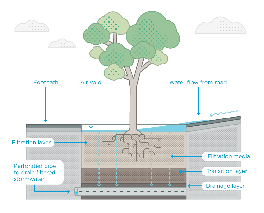
  • Installation of three new raingarden tree pits to capture stormwater runoff from Macarthur Street.
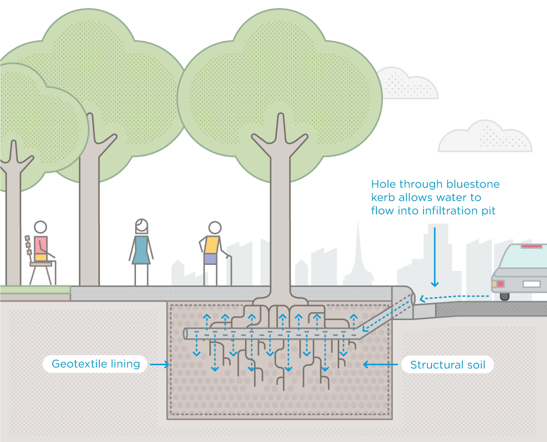
  • Installation of two soaker pits to capture runoff and direct it to four new trees.
  • Removing and replacing declining trees and planting additional trees.

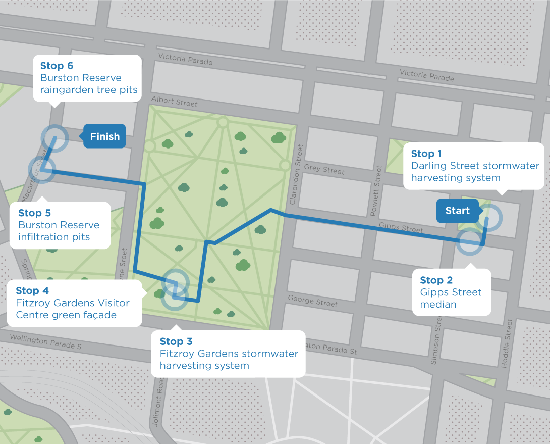
At Stop 1 you can see the three raingarden tree pits within the pavement. These trees are younger than most of the other trees in the reserve.

How do the raingarden tree pits work?

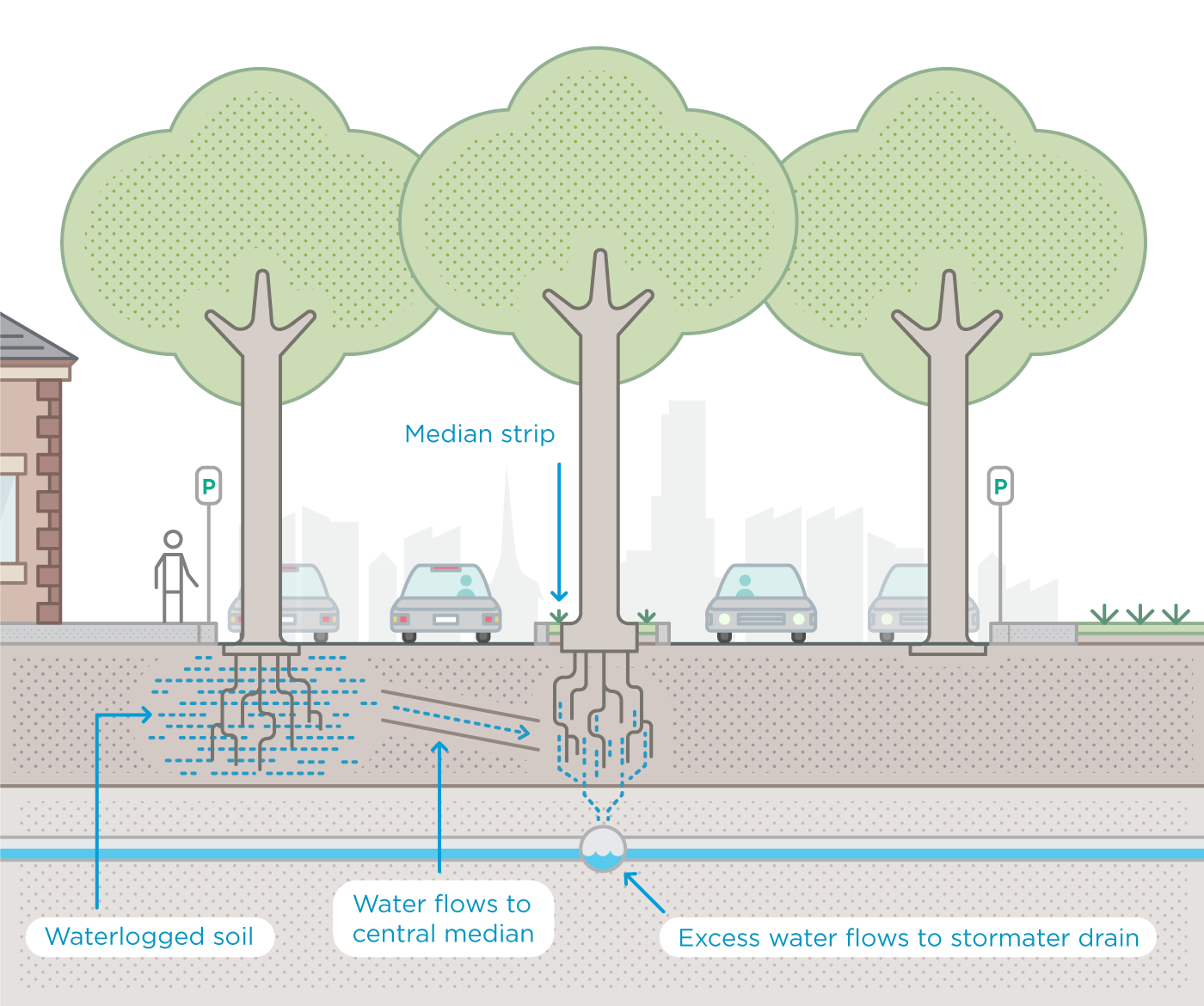
Each raingarden tree pit works like a small raingarden. When it rains, stormwater runs off road surfaces and into the gutters.

The raingarden tree pits are set into the kerb along Macarthur Street. They intercept and clean the water before it goes into the drain.

Each pit contains layers of substrate that work with the tree’s root system to filter pollution from the stormwater. This includes nitrogen, phosphorus and oils.

The tree pits also include a rock mulch layer to retain moisture in the soil and prevent erosion during rain.

A grate sits around the base of the tree, flush with the pavement. This protects the tree pit from damage and ensures that pedestrians don’t trip over it.

A pipe is located at the bottom of the well. It allows cleaned stormwater to drain back into the drainage system.

12981-CoM-Raingarden-infographic-Tree-Pit-1090px

This is the end of the tour!

Get social with the City of Melbourne
This website was delivered in partnership
with the State Government of Victoria
This website was delivered in partnership with the State Government of Victoria